Showing posts with label Personnel Location Tracking. Show all posts

Sunday, June 9, 2013

Mapping a Business on Bing Maps - IT Asset Mapping

Mapping a Business on the SharePoint Bing Mapper

IT assets mapped on the SharePoint
 Bing Mapper.


In this post we will be looking at mapping business assets on Bing Maps using the SharePoint Bing Mapper. This blog post will be building on the previous post, Mapping a Business on Bing Maps - Employee Mapping.  I will cover a few basics about using the tool and of course include a live demo.

Hopefully as I go through some of these features it will help spark ideas about how the mapper can help with business location information.  So far we have mapped the physical structure (the campus and the buildings), assigned employees to cubicals,  offices and work areas.  In this post we will be adding IT equipment to our map.  One point I want to stress is that the mapper has flexible data capabilities.  We could be adding power outlet locations, vending equipment or any other data to the map without ever going back to a developer.  

For this post I have added desktop computers and phone sets to the 2nd floor of building 1.  The same as with showing a person on the map, you can hover over the item to view the name and click it to get the detailed description.  Take a look at the included images to see how filtered views can be presented (for example, you might want to view only desktop computers over 3 years old).  And yes, you could use the mapped items to assign work orders (that would be slightly past out of the box capabilities but would by a fairly easy extension).  


Live demo of a filtered view showing phone systems at their installed location:


I have created a fairly simple demo, the detail popup as well as the Phone Systems table can be modified to include any desired data.

Here are a few more screenshots illustrating the features presented:
All persons and assets are
showing in this view.


A filtered view of IT assets showing
desktop computers.


A filtered view of IT assets showing
phone systems.


Adding a phone system to a IT
asset tracking list on the
SharePoint Bing Mapper.

Friday, May 31, 2013

Mapping a Business on Bing Maps - Employee Mapping

Mapping a Business on the SharePoint Bing Mapper 


In this post I will be demonstrating how to map a business on Bing maps.  This post will focus on showing employees on a Bing Map using indoor mapping, thereby creating a directory of employees.  In upcoming posts I will show other views that will include creating directories of conference rooms (including scheduling), mapping IT equipment to locations, etc.. 

Indoor map of an office on Bing Maps showing employee's assigned locations.

Live Demonstration!

Navigation Tips:
  1. Use the breadcrumb to select building, switch floors, change sites and zoom to offices.
  2. Use the search box in the Employee Directory list control to filter employees by name or job title.  Just enter the first few letters to narrow results.
  3. In the Employee Directory list highlighting an employee will center them on the map.
  4. Hovering over an employee will show their name.
  5. Clicking an employee will give you a detailed information.


Pretty neat stuff.  Seams to me that any business with with more than a handful of employees could use a director system like this.  Indoor mapping used to manage employees locations!  Great additions to an intranet and a great tool for HR.

Here is a series of screen shots of how easy it is to move employees from one location to another (switch offices or desks):

Select employee with a right click, select move from action menu.

Move the cursor to the new location and double click.


Confirm that you intended to move the employee.

That's it, the employee is now in their new location, directory updated!


Monday, April 1, 2013

SharePoint Mapper Indoor Mapping Demo

The SharePoint Mapper is both an Enterprise system and a cloud hosted mapping system.  The cloud hosted mapping system allows for the creation of complex, great looking maps that can be embedded in any website.  This feature basically eliminates the need to develop you own map hosting for your website.  Save money, save time...everyone is happy.

Whether you are looking to add a logo to a map or create a map application it is as simple as setting up an account, adding you content and embedding in your webpage.

I could blather on but instead I offer you this look at an embedded map: *  Map no longer embedded, click link for demo.

Adventure Works HQ Demo

Monday, March 18, 2013

Free Beer!!! Ok, not really...Free SharePoint Mapper Account!

The free trial offer has ended.  Thank you everyone.


So I can't actually give everyone free beer, sorry, but I can give you the next best thing:
A free trail account to use the Pdoc Tech SharePoint Mapper using Bing Maps!!!  I know you are excited now!

The Mapper is in Beta, somewhat ready to use and still ready for some more refinement.  So I want to give everyone a chance to play on the hosted version and see how easy it is to build great Bing Maps that are hosted in the SharePoint Mapper.

How to get your free Mapper trial:

  1. Either go to http://www.pdoctech.com/mapper and follow the links to subscribe or send me an email support@pdoctech.com.


Pretty simple.

Gratuitous image Pdoc Tech Bing Maps SharePoint Mapper.

Now remember, this is a free trial of a product in beta.  Feedback is encouraged, ask for help or guidance if you would like to try something or would like to know about extending the Mapper to accommodate custom functionality.

This offer is valid until it is no longer valid.


Saturday, January 19, 2013

Live Demonstrations of the SharePoint Bing Mapper!


I have opened up a site with two live demonstrations available.

It is available for a limited time at: PdocTech.com.  Please drop in and take a test drive.


Demonstration #1: The Ranch

Demonstration #2:  Adventure Works Headquarters


Please leave feedback on this post.

Saturday, November 3, 2012

Personnel Directory on Bing Maps

Personnel Directory on Bing Maps

In this webcast a directory of personnel working in a corporate headquarter is demonstrated.

The scenario is a single building with 3 levels being used by Adventure Works for their corporate headquarters.  They have decided to implement the SharePoint Bing Mapper Directory System on their internal corporate portal.  

Although the mapper can be used to map multiple locations and map items, in this scenario it will be used to map employees within the Adventure Works headquarters building.  

The video gives an end user perspective of employee locations.  Though the video shows what The Mapper looks like in action it doesn't cover possible uses for the information.

  1. Human Resources can use The Mapper to manage employee locations.  
    1. The task of assigning cubes and desks can be managed and tracked from a central location.  
    2. When employees are assigned or moved, updates to locations can be tracked through workflow to ensure location information is kept current and that all concerned parties (human resources, managers, facilities, etc) have access to it. 
  2. Reception - Using The Mapper, guests or other employees can quickly locate or be given directions to employee location or to meeting rooms.
  3. Security - In the event of an emergency, locating an assigned area become a quick and simple task, no longer relying on a key person to be able to give directions.


I hope you enjoyed the demonstration.  I have a couple of upcoming posts I will be putting up when I find the time.  I plan on doing a blog dedicated to the 101 Top Uses for The Mapper and another blog demonstrating using the blogger for a trade show registration.

Thanks Again!

Monday, September 10, 2012

Building Information Management vs. Building Information Modeling


Building Information Management vs. Building Information Modeling?

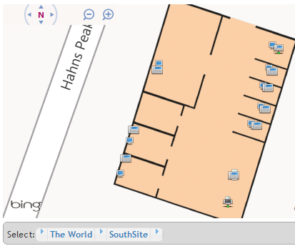
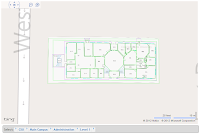
Personnel location information on the 
SharePoint Bing Mapper Directory System.
Recently I’ve embarked on creating this blog largely to discuss my latest project, the SharePoint Bing Mapper Directory System (“The Mapper” as I will refer to it in this post).  I want to be able to share my ideas on the concept of placing organizational information on a Bing Map.  Exploring the ideas behind The Mapper has led to some interesting quandaries.

 My big question is how to classify this application.  I have done a lot of research lately at looking in to the field of managing information around campuses, buildings, locations in general.  I keep finding myself looking the concept of building information modeling.  Building information modeling is an all-encompassing science that models in an architectural context of a building or buildings.  Different versions of BIM(odeling) include everything from the beginning of a project to cost and time information to full lifecycle and demolition planning.

That’s great, but how is that going to help the person sitting in the lobby of an office building filled with 1,000 workers?

How will it help the I.T. personnel charged with tracking equipment throughout the organization?

How will it help a HR person in locating a person in a building they’ve never seen before or to assign and track who sits at what desk, cubicle or office?

What about flexible spacing such as at trade shows?  Is  BIM(odeling) the answer to RAD style applications for managing those types of spaces?

This brings us to The Mapper and the concept of Building Information Management.  Might I be splitting hairs with the naming? Sure.  The concept I have worked through and created The Mapper to address is the stuff where we get down to usability type information.  This type of information is what an end user would consume.  This type of information relies on BIM(odeling) for accurate physical details (floor plans, site layouts, etc.) but is intended to convey business centric information coupled with building detail visualized on a web enabled map (in this case Bing Maps).
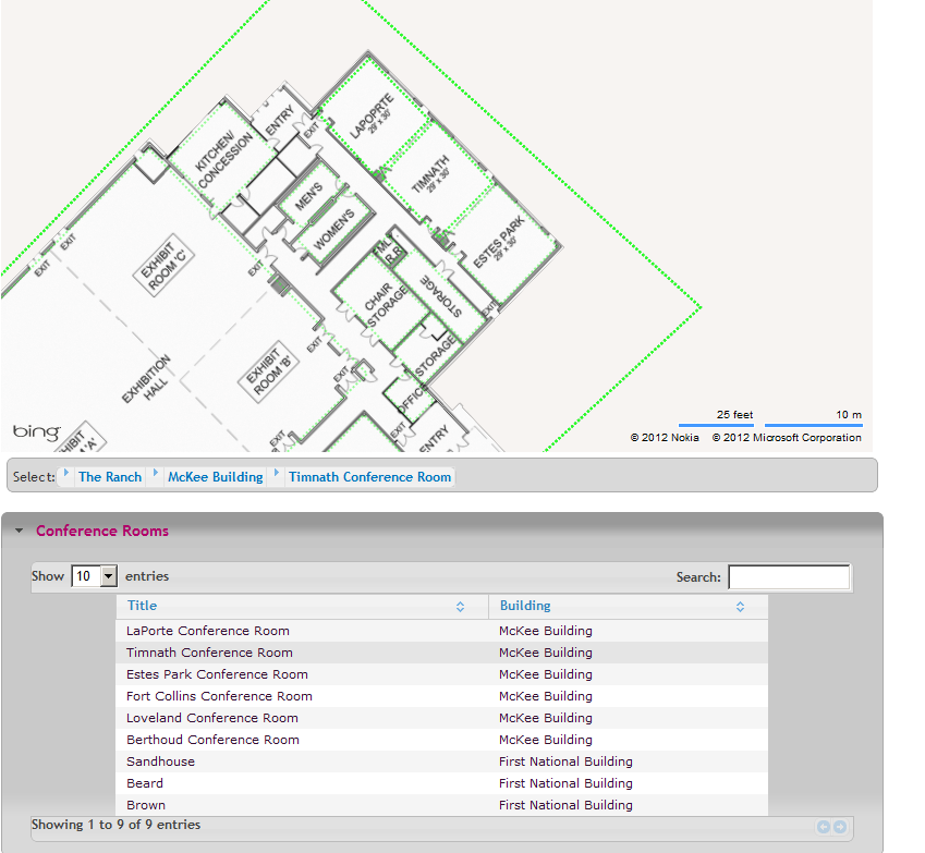
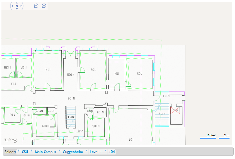
 Floor plan of the CSU Administration building on the SharePoint Bing Mapper Directory System.

BIM(anagement) is intended to be more service oriented, to provide answers to general users and to allow easy management of information related to people and items in relation to location.  The platform is designed to be extensible, making RAD development possible for information to be visualized on a map.

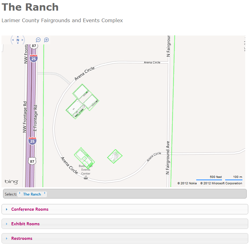
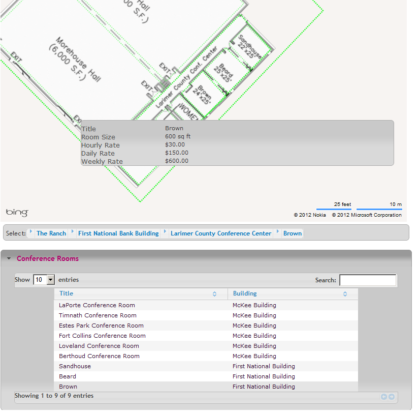
Envision this scenario:  An operator of a complex that hosts multiple conventions each year would like to automate the registration process for each convention.  By combining BIM(odeling) with a layout of the convention and making it available through a web browser the process can be streamlined.  The host can place booth availability, size, location and cost information on the map.  A registration form can be provided directly over the space on map, once the space is reserved it can be instantly marked as taken and provide the name of the occupant.  Using this same information, the show layout can be displayed on a public site as a directory for those attending the show.  The same information can also be used by maintenance crews for setup and teardown.  This is Building Information Management, the combining of the model with business scenarios.

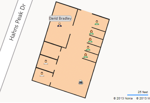
And since this is The SharePoint Mapper, a more SharePoint centric example:  SharePoint, for those who have not been initiated, by default contains people information and a search based profile tool.  When combined with The Mapper, you can retrieve a list of people with a link that can display where the persons assigned office/desk is located.  Okay, that is not a big deal if everyone in the company is sitting in the same building, however in a large organization with many campuses and many buildings it is a nice tool to have.  In this way The Mapper goes beyond BIM(odeling), combining multiple campuses to provide a map based contextual setting easily shared across an organization.

Geez, there you have it, my concept of Building Information Management…Perhaps it should be Organization Location Management…

SharePoint Bing Mapper Directory System Video Demo

SharePoint Bing Mapper Directory System


I have created two quick demos to give an idea of some of the basic functions of the system.

This first video demonstrates navigating around the map using the breadcrumb control and dragging the map. It also demonstrates how detailed information about an area can be provided in a popup.


This video demonstrates how navigation can be tied to a table control.  


These two demos give a small insight to how the system can present an end user with information on a Bing Map.  In the future I will put together a more comprehensive webcast about the Mapper.


Thursday, September 6, 2012

Introducing SharePoint Bing Mapper Directory System

SharePoint Bing Mapper Directory System

Personnel directory information
 visualized on a Bing Map.
Okay, the application name might need to be re-worked.  It is however a tough nut to put a name on.

It performs the following:

  • Building Information Modeling
  • Personnel Location Tracking
  • Asset Location Tracking
  • Interior Route Management (in development)
  • Directory Service for People
  • Directory Service for Buildings
  • Directory Service for Assets and Equipment (locate the printer with all the features you need or the conference room with that certain projector).
  • Facilities Management
To sum it up it is an Enhanced Bing Maps Enterprise Application.  

A big bonus?  Once the application is installed and configured almost no developer interaction is required.  Now that doesn't mean you can't have developer interaction.  The application allows for advanced styling (css and jQuery) and extension.  Tying map objects to additional pages or even integrating with outside applications via web services are both easily achievable.

In upcoming additions to this blog I intend to create demonstrations for a few of the applications described above...for now, I will leave you with a few screenshots.  


An office interior with personnel and office equipment combined on the map.
The popup is easily configured to show information specific to the map object,
in this case a printer has been clicked and the printer features are shown.


The Larimer County Fairgrounds building interiors mapped.
Notice the slide down menus provide a directory of rooms
by category.
A conference room has been select, centering the map over the
room.  The room has been clicked, opening a popup describing
the room and the rates to rent it.

So how to name something with such broad capabilities?  That is my quandary...feel free to ponder with me in the comments section.